Project Overview
Focused on Drilling Expansion of Shallow, Oxidized Silver-Gold Bulk Tonnage Mineralization with Potential for Deeper Silver-Polymetallic Sulfide Discovery
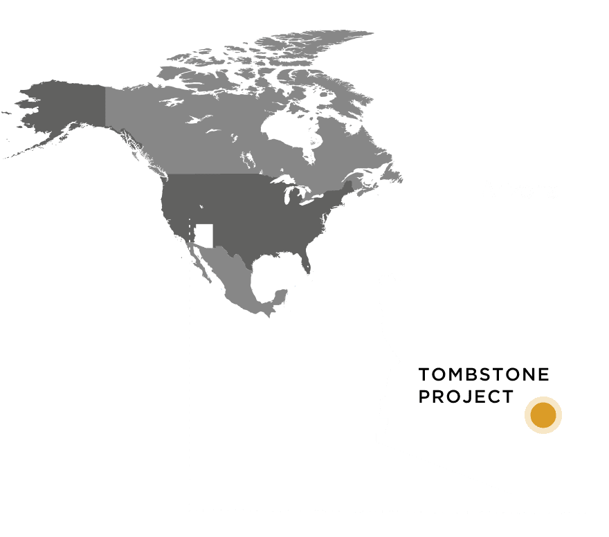
Aztec Minerals Corp. is advancing an exploration program on the Tombstone gold-silver project (85.0% JV interest) which is located 100 km southeast of Tucson, Arizona and covers much of the historic Tombstone silver-gold district and includes the brownfield Contention Pit mine site. The property spans across 2058 acres and consists of patented (46) and unpatented (73) claims. The project is accessible by road, includes water and power utilities and permitting for the exploration program and an aggregate operation. Within the Tombstone project is the Contention Pit, a past producing open pit heap leach oxide silver-gold mine that operated in the 1980’s and a number of historical pre-1950 silver-gold mines.
The main target of the current exploration program is expanding the shallow, bulk tonnage, historically heap leachable, mesothermal silver-gold oxide/sulfide mineralization adjacent to and below the Contention Pit and Westside workings through step-out drilling.
In addition, historical drill results and NSAM anomalies offer the potential for discovery of a deeper, sulphide high-grade silver-lead-copper-zinc Carbonate Replacement Deposits (CRD) 1. Tombstone is located in the heart of the Arizona world class porphyry copper region and is approximately 65 km northeast of the massive Hermosa-Taylor zinc-lead-copper-silver CRD deposit that became part of a $1.3 billion takeover completed by South32 in 2018.
Tombstone was renowned for its high grade, oxidized, silver-gold mesothermal stringer lode veins, hydrothermal breccias and manto CRD orebodies that were mined in the late 1800’s and early 1900’s. The historic production in the Tombstone district from 1878 to 1939 was estimated at 32 million ounces of silver and 250,000 ounces of gold 2, 65M pounds of lead, and 1.1M pounds of zinc, mostly from oxide ores.
Aztec has been successfully expanding the Contention and Westside target areas shallow oxide mineralization following along strike and dip extensions of the mineralized structures and bedding. It is anticipated that future targeting will move along those trends deeper into the sulfide zone as historically there was significant production to 300 m depth 2.
The district geology consists of a mix of shallow-level, oxidized silver-gold and base metal deposits related to CRD and skarns hosted in folded and thrusted sediments, intrusive dikes, hydrothermal breccias and lode veins, and as well the under explored, sulfide versions located below the water table.
Host rocks to the mineralization are primarily the clastic sediments of the lowest portion of the Cretaceous Bisbee Formation. Between 50 and 700 meters (m) in depth, the Bisbee is underlain by approximately two kilometres thick of the same Paleozoic carbonate formations that hosts 110 MT Hermosa-Taylor zinc-lead-silver deposit 3.
Aztec believes that the historic silver-gold mines at Tombstone could be related to a much larger porphyry driven mesothermal system with sulfide CRD mineralization below the historic mines. Since 2017, Aztec has completed geological mapping, geochemical sampling and geophysical surveying to identify the most prospective areas for silver-gold mineralization around and below the Contention Pit, and CRD zinc-lead-copper-silver-gold mineralization below the entire district. Aztec management views the district as highly prospective for the discovery of mesothermal lode, hydrothermal breccia and CRD mineralization.
Tombstone Project Highlights
- Brownfield Property Location on patented (46) and unpatented (73) claims (2058 acres), covers much of the historic Tombstone silver mining district that includes the past-producing Contention Pit. Access to infrastructure, local town, road, full services, water, power.
- Historic silver district2 produced 32 million ounces of silver and 250,000 ounces of gold from 1878-1939, in high grade, oxidized, silver-gold-lead-zinc-copper vein, breccia and CRD deposits, and small open pit heap leach production from the Contention Pit in late 1980’s.
- Drilling by Aztec in 2020-25 has demonstrated that the Contention Pit and Westside targets have significant, shallow oxidized Ag-Au bulk tonnage mineralization which is open in all directions. The 2025 drilling has shown the two targets merge and found zones of sulfide CRD mineralization. The 2026 drilling program is underway with an expanded budget.
- Multiple other prospective targets in the Cretaceous and Paleozoic sedimentary rocks related to major structural trends (NNE, NE, E-W).
- Jurisdiction: Arizona ranked 5th, out of 68 global jurisdictions, as the most attractive jurisdiction for mining investment in the Fraser Institute’s Annual Mining Survey Investment Attractiveness Index released on February 26, 2026.
* Aztec has not verified these historic results and is not relying on them. Aztec has the historic drill logs, maps and reports but does not have any information on the quality assurance or quality control measures taken in connection with these historical exploration results.
Noted References:
1. “Zonge International, AMT Survey, Tombstone Project, Cochise County, AZ, Data Acquisition and Processing Report, Prepared for Aztec Minerals, 18 May 2020, Zonge Job #20013”
2. Greeley, Michael N., A Brief History and Review of Ore Grades and Production in the Tombstone Mining District with Emphasis on the Contention Mine Area, June 1984
3. M3 Engineering and Technology Corp., Hermosa Project N.I. 43-101F1 Pre-Feasibility Study, January 2014
Project Details
Property and Location
Aztec Minerals holds an 85.0% interest in the Tombstone Property Joint Venture and is the project operator. The property is located approximately 100 km southeast of Tucson in Cochise County, southeastern Arizona, and covers much of the historic Tombstone silver-gold district, including the brownfield Contention Pit mine site. It comprises 2,058 acres of patented (46) and unpatented (73) claims. The project is road accessible, with water and power utilities, full services in the adjacent town of Tombstone, a permitted aggregate operation, and permitting in place for the current exploration program. Tombstone lies in the heart of the Arizona porphyry copper region and is approximately 65 km northeast of the massive Hermosa-Taylor zinc-lead-copper-silver carbonate replacement deposit (CRD), which became part of a US$1.3 billion (C$1.8 billion) takeover of Arizona Mining by South32 in 2018.
History and Past Production
The Tombstone district was renowned for its high-grade, oxidized, silver-gold mesothermal stringer lode veins, hydrothermal breccias and manto CRD orebodies, mined in the late 1800s and early 1900s. Historic production from 1878 to 1939 is estimated at 32 million ounces of silver and 250,000 ounces of gold, together with 65 million pounds of lead and 1.1 million pounds of zinc, mostly from oxide ores (Crossey, 1984). The Contention Mine was historically the largest in the district, with underground workings exploiting high-grade silver-gold mineralization to roughly 300 m depth. A small open-pit heap-leach operation produced gold and silver from the Contention Pit in the late 1980s. Most historic mining terminated near the base of the Bisbee Formation at the water table because of flooding and pumping limitations, leaving the deeper section under-explored.
Geology and Mineralization
District geology consists of a mix of shallow, oxidized silver-gold and base-metal deposits related to carbonate replacement and skarn mineralization, hosted in folded and thrust-faulted sediments, intrusive dikes, hydrothermal breccias and lode veins, with under-explored sulfide equivalents below the water table. Three styles of mineralization are recognized:
- Bulk-tonnage mesothermal silver-gold oxide and sulfide mineralization in the lower Cretaceous Bisbee Formation around and below the Contention Pit, associated with quartz-feldspar porphyry dikes. This is the focus of the current drilling program.
- High-grade silver-gold-lead (zinc-copper) fissure veins and mantos in the lowermost Bisbee Formation, which hosted most of the historic mines.
- Deeper carbonate replacement deposit (CRD) potential in the underlying Paleozoic limestones.
Host rocks are primarily the clastic sediments of the lowest portion of the Cretaceous Bisbee Formation. Between approximately 50 and 700 m depth, the Bisbee is underlain by about 2 km of the same Paleozoic carbonate formations that host the 110 Mt Hermosa-Taylor zinc-lead-silver deposit (M3 Engineering, 2014). The mineralization observed in drilling is low-sulfidation and mesothermal, marked by hydrothermal breccias, quartz veining and silicification associated with the porphyry dikes, with potassic, argillic, hornfels and skarn alteration. Silver chloride (cerargyrite) is observed in fractures, often with fine-grained visible gold.
Exploration and Drilling
Since 2017, Aztec has completed geological mapping, geochemical sampling and geophysical surveying, including a natural-source audio-magnetotelluric (NSAMT / AMT) survey (Zonge International, 2020), to identify the most prospective areas for silver-gold mineralization around and below the Contention Pit and for CRD silver-lead-copper-zinc-gold mineralization beneath the district. Drilling by Aztec between 2020 and 2026 totals more than 130 holes and over 25,000 m. This drilling has outlined wide, shallow, oxidized gold-silver mineralization along more than 1,000 m of strike, up to about 400 m wide and to roughly 265 m depth around the Contention Pit, open in all directions and at depth. Aztec has successfully expanded the Contention and Westside target areas along the strike and dip extensions of the mineralized structures and bedding. Drilling in 2025 indicated that the two target areas merge and intersected zones of sulfide CRD mineralization.
Current Drilling Program (2025 to 2026)
The 2025 to 2026 drilling program is underway with an expanded budget. As reported, 78 holes (about 16,200 m) had been completed with assay results released for 55 holes and further results pending as drilling continued. The program steps out near the Contention Pit to expand the known bulk-tonnage gold-silver mineralization horizontally and down-dip, and includes the first core drilling of the deeper CRD sulfide target from reverse-circulation pre-collars. In May 2026, the Joint Venture approved a further 3,500 m of reverse-circulation drilling, bringing the planned program to approximately 22,200 m of combined core and RC drilling.
Selected Drill Highlights
Recent drilling has returned high-grade gold and silver intercepts within the broad, shallow oxide zone. Selected results:
- TR25-17: 5.16 g/t Au and 39.12 g/t Ag (5.72 g/t AuEq) over 57.8 m, including 58.5 g/t Au and 173.1 g/t Ag over 4.6 m (news release, 7 January 2026).
- TR21-03: 5.71 g/t Au and 40.54 g/t Ag (6.28 g/t AuEq) over 32.0 m.
- TR21-22: 2.44 g/t Au and 66.56 g/t Ag (3.39 g/t AuEq) over 65.5 m.
- TR24-16: 3,669 g/t Ag and 44.7 g/t Au over 1.52 m (7,269 g/t AgEq), within 290 g/t Ag and 3.48 g/t Au over 25.8 m, the highest silver grade encountered in drilling at Tombstone.
- TC23-01: 3,477 g/t Ag over 1.52 m within 733.9 g/t Ag over 7.6 m; and 0.58 g/t Au and 72.19 g/t Ag (1.63 g/t AuEq) over 125.0 m.
- TC23-05: 2.82 g/t Au and 176.64 g/t Ag (5.02 g/t AuEq) over 36.0 m.
Gold-equivalent (AuEq) and silver-equivalent (AgEq) values use a silver-to-gold ratio of 80:1 for 2020 and 2023 results and 70:1 for 2021 results. Reported intervals are apparent (drill-indicated) widths, not true widths.
Deeper Sulfide and CRD Potential
Historic moderate-depth drilling and AMT geophysical anomalies indicate the potential for a deeper, sulfide, high-grade silver-lead-copper-zinc CRD system below the historic oxide mines. Historic core holes drilled by Newmont and Santa Fe in the 1950s and in 1989 intersected deep, narrow to medium-width, high-grade silver-polymetallic CRD mineralization; the best, hole T-8, returned 7.2 m of approximately 9.1% combined lead-zinc (6.5% Pb and 2.6% Zn), 32 g/t silver and 0.61% copper. The NSAMT survey imaged a large conductor below the Contention Pit and Bisbee sediments within the Paleozoic limestones, with CRD targets interpreted from roughly 400 m to beyond 1,000 m depth. Tombstone is considered a close geological analogue to the Hermosa-Taylor deposit located approximately 65 km to the southwest, and Aztec management views the district as highly prospective for the discovery of mesothermal lode, hydrothermal breccia and CRD mineralization.
Project Maps


